So I headed up north for my birthday weekend. Not all the way to North Korea, but I wasn't too far away from it. In fact, the town I stayed in, which is called Sokcho ( 속초 ), is north of the 38th parallel and was part of North Korea throughout the Korean War. Living in Waegwan, I've never really thought twice about the fact that South Korea is still technically at war with North Korea. But heading up north provides some more reminders of the ongoing conflict. The beaches are almost completely lined with barbed wire, there are soldiers marching along the beach, and there are guard posts and spotlights running along the shore. I think the last incident in this area occurred in 1996, so it's not exactly a hostile environment, but it's still a little intimidating to head into that sort of area. But anyway, let's get to the good stuff: Seorak Mountain.
 |
| The shoreline was almost completely lined with barbed wire |
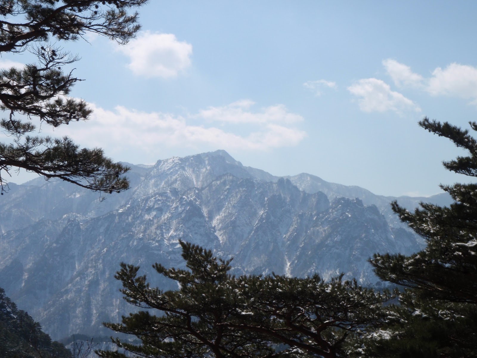
Mount Seorak is part of the Taebaek mountain range and is probably the most well-known mountain in South Korea. Seoraksan is the highest mountain in the Taebaek mountain range at 5,600 feet and is also the third highest in all of South Korea. However, Seorak's rock formations are the reason it is famous. In particular, Ulsan Rock ( 울산바위 ) is absolutely gigantic and serves as an iconic image for the Korean peninsula. There are three separate areas of the mountain to climb and I decided to climb at Outer Seorak this time. This is the most popular area of the mountain and there are four routes that can be traveled from the base. I of course traveled all four and I've provided a recap of the events below.
 |
| At the bottom of the mountain |
So the journey began at 11:05 Thursday night when I caught an overnight bus from Daegu to Gangneung. I arrived in Gangneung around 4:30 (to be honest I'm not really sure what time it was cause I was a little out of it) and proceeded to grab some food and chill out until I caught the first bus to Sokcho at 5:50. I got into Sokcho around 7:00 and finally made it to the mountain by 7:45.
 |
| Entrance to Seoraksan |
The first stop on my tour of Mt. Seorak was Biryong Pokpo ( 비룡폭포 ), which means Flying Dragon Waterfall and is the most accessible trail from the Outer Seorak base. It only takes about 45 minutes to reach the waterfall and you pass Yukdam Pokpo ( 육담폭포 ), which is a serious of six small waterfalls, on the way. Most of the trail is very easy and it was a good way to start the day after a long night of traveling.
 |
| Bridge leading to Biryong Pokpo |
 |
| Rock formation on the way to the waterfall |
 |
| Biryong Pokpo |
After getting back to the base I made a quick stop at The Great Unification Buddha ( 통일대불 ) and Sinheung Temple ( 신흥사 ). This temple area is right at the base of the mountain, so I ended up stopping here multiple times and got some great photos each time.
 |
| Jeungjang Cheonwang (King Jeungjang) |
 |
| Sinheungsa and Seoraksan |
 |
| Inside the Main Hall |
 |
| Great Unification Buddha |
After this quick detour, I started my trip to Geumgang Cave ( 금강굴 ). A river and a rock formation called Biseondae were both along the route and provided some nice pictures. Overall, this was definitely a more strenuous hike than the previous walk to Biryong Pokpo. Nothing too terrible, but it's a lot higher up the mountain than the waterfall.
 |
| Panorama view |
 |
| Inside Geumganggul |
It started snowing on my way back down from Geumganggul, but at first it seemed like nothing more than a light snowfall. I had planned to make the trip to Ulsanbawi in the afternoon and I decided that I wasn't gonna let a little snowfall get in my way. This proved to be the wrong decision as the snow continued to come down harder and harder. After hiking for about a half hour to Ulsanbawi I decided that it was probably best to turn back and try again on Saturday. So I made my way to the bus stop and caught a bus to Sokcho. The snow had subsided for the most part by the time I got into Sokcho, so I caught another bus to Naksan Provincial Park ( 낙산 도립공원 ). This park is home to a temple complex that is located right on the Sea of Japan and which therefore provides some amazing views. This temple was originally built in 671 and is home to numerous buildings and statues.
 |
| Hongreanam |
 |
| Bodhisattva of Mercy |
 |
| Bell Tower |
 |
| Entrance |
Naksansa was my last adventure for the day and I later found my way back to Sokcho and got a hostel room for the night.
I slept in a little later than I wanted on Saturday and ended up making it to the mountain around 10:00. Saturday was an absolutely beautiful day and the first thing on my agenda was hiking up to Ulsanbawi. Now this is hiking. The trip to the top is much more taxing than the other two routes. It takes about an hour to reach the bottom of the rock from base of the mountain. And that's when the fun begins. 888 steps of fun from the bottom to the top. It's a pretty tough journey and it wasn't made any easier by the fact that the ground was covered in snow. But I got to the top about an hour after I began and it was definitely worth every ounce of energy I expended making the trip.
 |
| On the way up |
 |
| Ulsanbawi |
 |
| I couldn't have asked for a nicer day |
I arrived back at the base around 2:00 and I had one more adventure to go. I took a ride on a cable car to Gwongeum Fortress ( 권금성 ). This is obviously the easiest trek considering that most of the journey is made in a cable car. However, actually getting to the top of Gwongeumseong proved to be somewhat difficult. Unlike the hike to Ulsanbawi, there are no stairs provided for the trip. Nonetheless, I made it to the top and got some spectacular pictures as a result. This trek concluded my two-day jaunt at Seoraksan and I headed back to my hostel around 5:00.
 |
| Cable car |
 |
| At the top of Gwongeumseong |
I woke up at 5:30 on Sunday and took a ten minute stroll to the shore to see the sunrise on the Sea of Japan. It was a little tough to get up this early, but it was clear morning and I got to see a beautiful sunrise.
I then caught the 7:00 bus out of Sokcho and arrived in Gangneung about an hour later. From Gangneung I caught a bus to a place called Jeongdongjin ( 정동진 ), which is home to Gangneung Unification Park. This park houses a North Korean submarine, which ran aground in 1996 while spying on South Korea. There were 26 soldiers in the submarine and all but one of these soldiers were found after a 49 day manhunt. There is also a South Korean warship and a tiny boat used by North Koreans to escape from their country on display.
 |
| On board a South Korean warship |
 |
| North Korean submarine |
And thus comes to an end my weekend in the northeast. All I had left to do was sit on a bus for six hours as I traveled back to Daegu. This weekend provided the most amazing views that I have seen in Korea and I plan on going back to Seoraksan in May or June and then again in October. I would definitely recommend this trip to anyone looking to explore Korea beyond the confines of the Seoul Metropolitan Area.


Informative. Thanks....for sharing
ReplyDelete